Introduction
Are you curious about the world of drone surveying? Wondering who exactly a drone surveyor is and what they do? Look no further! In this article, we will explore the role of a drone surveyor and delve into the fascinating world of UAV technology for surveying.
Drone surveyors play a crucial role in various industries such as construction, agriculture, and mapping. They utilize unmanned aerial vehicles (UAVs), commonly known as drones, to collect high-resolution images and data from above. These skilled professionals are trained to operate drones equipped with advanced sensors and cameras that can capture detailed aerial imagery.
By analyzing this data, drone surveyors provide valuable insights for decision-making processes in fields like land development, environmental monitoring, and infrastructure planning. If you’re interested in becoming a drone surveyor or simply want to learn more about this exciting field, keep reading to discover the key skills needed and the best drones available for effective surveying.
The Role of a Drone Surveyor
So, you’re interested in becoming a drone surveyor, huh? Well, let me tell you all about the crucial role you’ll play in capturing accurate and detailed data from above!
As a drone surveyor, your primary responsibility is to use drones for surveying purposes. These unmanned aerial vehicles (UAVs) equipped with high-resolution cameras or LiDAR sensors allow you to collect precise data that can be used for various applications such as land mapping, construction site inspections, and environmental monitoring.
One of the key advantages of being a drone surveyor is the ability to capture data from areas that are difficult or dangerous to access on foot. With drones, you can easily fly over large areas of land and capture images or create 3D models with exceptional accuracy. This not only saves time but also provides more comprehensive information compared to traditional surveying methods.
To excel as a drone surveyor, it’s important to have a strong understanding of both aviation regulations and mapping techniques. You need to be familiar with airspace restrictions and obtain the necessary certifications or licenses required by your country’s aviation authority. Additionally, having knowledge of photogrammetry or LiDAR processing software will help you process the collected data effectively.
Understanding UAV technology for surveying is crucial for your success as a drone surveyor. Drones come in various sizes and configurations, each suited for different types of surveys. Some drones are designed specifically for mapping applications with advanced features like waypoint navigation systems and automated flight planning tools. By utilizing these technologies effectively, you’ll be able to optimize your workflow and deliver accurate results efficiently.
Now that you have an idea about the role of a drone surveyor and how important it is in collecting precise data using drones for surveying purposes, let’s delve into understanding UAV technology further.
Understanding UAV Technology for Surveying
To truly grasp the ins and outs of UAV technology for surveying, picture yourself effortlessly navigating through the sky, capturing precise data from above with cutting-edge equipment. Drones used for surveying are equipped with advanced sensors and cameras that can capture high-resolution imagery and collect accurate measurements.
These unmanned aerial vehicles (UAVs) are revolutionizing the field of surveying by providing a cost-effective and efficient way to gather data over large areas.
One of the key features of UAV technology is its ability to generate detailed 3D models and maps. By using photogrammetry techniques, drones can capture multiple images from different angles and create highly accurate 3D representations of terrain, buildings, or any other objects on the ground. This allows surveyors to analyze topography, identify potential hazards, and plan construction projects with precision.
Moreover, drones have the capability to carry different types of sensors such as LiDAR (Light Detection and Ranging), thermal cameras, or multispectral cameras. These sensors enable drone surveyors to obtain additional information beyond visual imagery. For example, LiDAR can measure distances between the drone and objects on the ground by emitting laser pulses, while thermal cameras can detect heat signatures that may indicate energy loss in buildings. The combination of various sensors provides a comprehensive understanding of the surveyed area.
With this understanding of UAV technology in mind, let’s delve into key skills and training for drone surveyors without skipping a beat.
Key Skills and Training for Drone Surveyors
Imagine being a modern-day cartographer, armed with the aerial equivalent of a paintbrush, skillfully capturing every contour and detail of the land below with your unmanned winged assistant. As a drone surveyor, you possess key skills and training that allow you to efficiently operate drones for surveying purposes. These skills include proficiency in flight operations, data processing, and analysis. With these abilities at your disposal, you’re well-equipped to provide accurate and detailed information about various landscapes.
To excel as a drone surveyor, it’s essential to have expertise in flight operations. This involves understanding the mechanics of drones and their navigation systems. You must be able to fly the drone smoothly while maintaining control over its movements. Additionally, knowledge of airspace regulations is crucial to ensure safe and legal operation of the drone during surveys.
Data processing is another vital skill for drone surveyors. After conducting aerial surveys, you need to process the collected data into usable formats such as maps or 3D models. This requires proficiency in specialized software that can handle large datasets efficiently. Furthermore, understanding geospatial concepts enables you to accurately analyze the collected data and extract meaningful insights.
Incorporating an unordered list:
- Proficiency in flight operations
- Knowledge of airspace regulations
- Expertise in data processing
- Understanding of geospatial concepts
With these skills under your belt as a drone surveyor, you’re ready to tackle the next step: choosing the right drone for your surveying needs. Factors such as flight time, payload capacity, camera quality, and durability should be considered when selecting a drone for surveying purposes. By carefully evaluating these factors based on your specific requirements, you can ensure that your chosen drone will effectively support your work as a skilled aerial cartographer.
Factors to Consider When Choosing a Drone for Surveying
When selecting a drone for surveying, it’s important to consider factors such as flight time, payload capacity, camera quality, and durability. Flight time is crucial because longer flights allow for more extensive surveys without needing to constantly recharge or replace batteries.
Payload capacity is also essential as it determines the weight of equipment the drone can carry, such as high-resolution cameras or LiDAR sensors. Additionally, camera quality plays a significant role in capturing accurate and detailed imagery during surveys.
Lastly, durability is vital since drones must withstand various weather conditions and potential collisions with obstacles on the ground.
Another factor to consider when choosing a drone for surveying is the ability to integrate with mapping software and data processing tools. Many surveying tasks involve collecting data that needs to be processed into usable maps or 3D models. Therefore, ensuring compatibility between your chosen drone and the software you will use for data analysis is crucial. This allows for seamless integration of captured images or LiDAR scans into your preferred mapping workflow.
Furthermore, it’s essential to evaluate the ease of use and versatility of the drone you select. Look for features like obstacle avoidance systems that enhance flight safety and prevent accidents during surveys in complex environments. Additionally, having intelligent flight modes can help automate certain tasks like waypoint navigation or follow-me functions, enabling efficient data collection without requiring constant manual control.
Considering these factors when selecting a drone will help ensure that you choose one suitable for your specific surveying needs. In the next section about ‘top features to look for in surveying drones,’ we will explore additional aspects that are worth considering before making your final decision on which drone to purchase.
Top Features to Look for in Surveying Drones
Consider the wingspan of an eagle when searching for a surveying tool that boasts exceptional range and coverage. When it comes to surveying drones, one of the top features to look for is a long flight time. This allows you to cover more ground in a single flight, saving you time and increasing efficiency.
Look for drones that have a flight time of at least 30 minutes or more, as this will give you ample time to complete your surveys without needing to constantly land and recharge.
Another important feature to consider is the camera quality. A high-resolution camera will ensure that you capture detailed and accurate images during your surveys. Look for drones that have cameras with at least 12 megapixels or higher, as this will provide clear and crisp images. Additionally, some drones offer built-in image stabilization technology, which can help reduce blur caused by drone movement or wind gusts.
Lastly, take into account the durability and stability of the drone. Surveying often requires flying in challenging environments or adverse weather conditions. Therefore, it’s crucial to choose a drone that can withstand these conditions without compromising its performance. Look for drones with strong frames and advanced GPS systems that allow for precise positioning even in windy conditions.
Considering these top features will help you find a surveying drone that meets your needs perfectly. Now let’s move on to comparing different drone models for surveying purposes without wasting any more time!
Comparing Different Drone Models for Surveying
Now, let’s dive into the world of surveying drones and explore how different models can revolutionize your data collection process.
When comparing different drone models for surveying, there are several factors to consider. One important factor is the drone’s flight time and range. A drone with a longer flight time and range will allow you to cover larger areas in one flight and collect more data without needing to recharge or change batteries frequently.
Another important feature to look for is the drone’s camera capabilities. High-resolution cameras with advanced imaging sensors can capture detailed aerial images, which are crucial for accurate mapping and modeling. Some drones also come equipped with specialized cameras such as thermal cameras or multispectral cameras that can provide additional data beyond just visual imagery.
Lastly, it’s essential to consider the drone’s stability and maneuverability. A stable and agile drone will be able to fly smoothly even in challenging weather conditions or complex terrains, ensuring reliable data collection. Look for drones with advanced flight control systems, obstacle avoidance technology, and GPS positioning for precise navigation.
Now that you have an idea of what features to look for in surveying drones, let’s move on to exploring the successful applications of drone surveying in various case studies.
Case Studies: Successful Applications of Drone Surveying
Explore how different models of surveying drones have transformed data collection processes, allowing you to cover larger areas, capture detailed imagery, and navigate challenging conditions with ease.
Construction Site Survey
One successful case study is the use of the DJI Phantom 4 Pro drone in a construction site survey. With its advanced obstacle avoidance technology and high-resolution camera, this drone was able to collect accurate data quickly and safely in a complex environment. The resulting imagery allowed for better project planning and monitoring.
Benefits of Drones in Construction Site Surveying
1) Land Surveying/Cartography:
-
- Generates high-resolution orthomosaic maps and 3D models.
- Creates accurate cadastral maps and provides information for sites with limited or outdated data.
2) Land Management and Development:
-
- Simplifies topographic surveys for land management and planning.
- Facilitates site scouting, allotment planning, and design of roads, buildings, and utilities.
- Transfers data to CAD or BIM software for pre-construction engineering studies.
3) Precise Measurements:
-
- Enables highly accurate distance and surface measurements using high-resolution orthomosaic photos.
4) Volumetric Measurements:
-
- Utilizes drone images in 3D mapping software to obtain volumetric measurements.
- Primarily used for calculating stocks in mines and quarries for inventory or monitoring purposes.
5) Slope Monitoring:
-
- Generates Digital Surface Models (DSM) and Digital Terrain Models (DTM) for slope measurement extraction.
- Detects changes in earth’s movement and measures velocity.
- Helps monitor slopes for landslide mitigation and prevention, predicting landslides, and preventing potential damage to infrastructure.
6) Urban Planning:
-
- Assists urban planners in quickly collecting up-to-date data of complex urban areas with minimal staff.
- Helps analyze existing social and environmental conditions for easier planning of urban development.
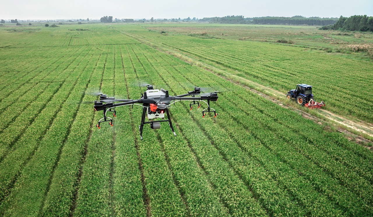
Agricultural Survey
Another example of a successful application is the use of the Autel Evo II drone for agricultural surveys. This drone’s long flight time and thermal imaging capabilities enabled farmers to assess crop health more efficiently. By capturing detailed images from above, they were able to identify areas of concern such as pest infestations or irrigation issues, leading to targeted interventions and improved yields.
Environmental survey
In addition to construction and agriculture, drones have also been used effectively in environmental surveys. The senseFly eBee X drone has been employed for mapping wildlife habitats in remote locations. Its ability to withstand harsh weather conditions and cover large areas quickly made it an ideal tool for conservationists. By collecting precise data on habitat size and distribution, researchers were able to make informed decisions about land management strategies.
As these case studies demonstrate, different models of surveying drones have revolutionized data collection processes across various industries. They provide an efficient way to gather accurate information over large areas while overcoming challenges such as difficult terrain or inaccessible locations. Now that you are familiar with some successful applications of drone surveying, let’s explore tips for effective data collection and analysis without delay.
Tips for Effective Data Collection and Analysis
Let’s dive into some handy tips for collecting and analyzing data efficiently, so you can make the most out of your surveying adventures!
- Plan ahead: Before heading out to collect data with your drone, it’s important to plan your mission carefully. Identify the specific areas you need to survey and create a flight path that covers them effectively. Take into consideration any obstacles or potential hazards that may affect your data collection process. By planning ahead, you’ll save time and ensure accurate results.
- Use proper settings: To capture high-quality data, make sure you adjust your drone’s camera settings accordingly. Set the appropriate resolution and image format for the type of survey you’re conducting. Additionally, consider using bracketed exposures or HDR mode to capture more detail in challenging lighting conditions. These settings will help produce accurate and clear images for later analysis.
- Establish ground control points (GCPs): GCPs are reference markers on the ground that help improve accuracy in mapping or modeling projects. By placing these markers strategically throughout the area being surveyed, you provide reference points for georeferencing aerial imagery accurately. Make sure to measure their coordinates precisely using GPS devices or other reliable methods.
- Invest in post-processing software: Once you’ve collected all the necessary data with your drone, it’s vital to have suitable software for processing and analyzing it effectively. Look for professional-grade software that allows you to stitch together images, generate 3D models, perform measurements, and extract valuable insights from your survey data easily.
By following these tips for effective data collection and analysis, you’ll be well-equipped to maximize the value of the information obtained through drone surveys. Now let’s explore how ensuring safety and compliance is an essential aspect of successful drone surveying adventures!
Ensuring Safety and Compliance in Drone Surveying
To ensure a safe and compliant drone surveying experience, you need to prioritize safety measures and adhere to all relevant regulations, allowing you to confidently navigate potential objections and protect both yourself and others.
First and foremost, always conduct a thorough pre-flight inspection of your drone equipment. Check for any damage or malfunctions that may pose a risk during the surveying process.
Additionally, make sure you have obtained all necessary permits and permissions from local authorities before flying your drone in designated areas.
During the actual surveying operation, it’s crucial to maintain situational awareness at all times. Keep an eye out for any obstacles or hazards that could interfere with your flight path. Be mindful of nearby buildings, power lines, or other structures that may be in close proximity to your survey area. By being aware of your surroundings, you can prevent accidents and minimize the chances of damaging property or causing harm.
Furthermore, staying up-to-date with the latest regulations and guidelines for drone operations is essential for ensuring compliance. Laws regarding airspace usage and privacy rights can vary depending on the jurisdiction you’re operating in. Stay informed about any changes or updates in these regulations to avoid legal issues and potential fines.
By prioritizing safety measures and complying with regulations, you can conduct drone surveys confidently while minimizing risks.
Transition: Looking ahead at future trends and innovations in drone surveying, it’s important to stay abreast of technological advancements that may further enhance safety protocols and improve data collection efficiency without compromising compliance requirements.
Future Trends and Innovations in Drone Surveying
One exciting development in the field of aerial mapping is the integration of artificial intelligence or AI. This has the potential to revolutionize data analysis and streamline surveying processes. With AI algorithms, drones can now autonomously analyze images and videos captured during surveys, allowing for faster and more accurate data processing. This eliminates the need for manual interpretation by surveyors, saving both time and resources.
Another trend in drone surveying is the use of advanced sensors and cameras. Drones equipped with LiDAR sensors can create highly detailed 3D maps by measuring distances between objects using laser pulses. This technology enables surveyors to capture precise measurements of land features from above, improving accuracy and efficiency in mapping applications. Additionally, thermal imaging cameras are being integrated into drones for improved infrastructure inspections and environmental monitoring.
Furthermore, there is a growing focus on developing drones that can carry out autonomous flight operations. These drones are programmed to follow pre-determined flight paths while avoiding obstacles in real time. By reducing human intervention during flights, autonomous drones enhance safety and productivity in surveying operations. The ability to program automated missions also allows for consistent data collection over time, enabling better analysis of changes or trends in surveyed areas.
The integration of AI technology, advanced sensors, and autonomous flight capabilities are driving future advancements in drone surveying. These innovations promise faster data analysis, higher accuracy in mapping applications, improved safety measures during flights, and increased efficiency overall. As these trends continue to evolve, drone surveyors can expect even greater advancements that will enhance their ability to collect accurate data for various industries such as construction management, environmental monitoring, agriculture planning, and infrastructure inspections among others.
Frequently Asked Questions (FAQs)
How much does it cost to hire a drone surveyor?
To hire a drone surveyor, the cost can vary depending on several factors such as the location, duration of the survey, and specific requirements. Typically, drone surveyors charge an hourly rate or a fixed fee for their services.
On average, you can expect to pay anywhere from $100 to $300 per hour for a professional drone surveyor. However, it’s important to note that additional costs may be incurred for data processing and analysis.
It is recommended to reach out to different drone surveying companies and compare quotes to find the best option that suits your needs and budget.
What are the legal requirements for operating a drone for surveying purposes?
To legally operate a drone for surveying purposes, you need to comply with certain requirements. First and foremost, it’s crucial to obtain the necessary certifications and licenses.
In most countries, this involves obtaining a remote pilot certificate or drone operator license. Additionally, you must register your drone with the appropriate regulatory body.
It’s essential to familiarize yourself with the local aviation regulations and airspace restrictions governing drone operations. Adhering to these rules ensures safe and responsible drone surveying practices while avoiding potential legal issues.
Can a drone surveyor provide accurate measurements for land surveying?
Can a drone surveyor provide accurate measurements for land surveying? Absolutely!
Drone surveyors are equipped with advanced technology that allows them to capture high-resolution aerial imagery and collect precise data. Using specialized software, they can process this data to generate accurate measurements of the land, including distance, area, and elevation.
Drones offer several advantages over traditional surveying methods, such as speed, cost-effectiveness, and accessibility to hard-to-reach areas. With their ability to fly at different altitudes and angles, drones can cover large areas in a short amount of time while providing detailed information.
So if you’re looking for accurate measurements for your land surveying needs, a skilled drone surveyor is definitely the way to go!
Are there any limitations to using drones for surveying in certain weather conditions?
There can be limitations to using drones for surveying in certain weather conditions.
For example, strong winds can affect the stability and control of the drone, making it difficult to obtain accurate measurements.
Rain or snow can also interfere with the drone’s sensors and cameras, potentially reducing the quality of the data collected.
Additionally, foggy or cloudy conditions may limit visibility and make it challenging to capture clear images or videos.
It’s important for drone surveyors to consider these weather factors and assess whether it’s safe and feasible to conduct surveys in such conditions.
Can drone surveyors provide 3D mapping and modeling services?
Yes, drone surveyors can absolutely provide 3D mapping and modeling services. With their advanced technology and aerial capabilities, drones are able to capture high-resolution images and data from various angles. This allows them to create accurate and detailed 3D maps and models of landscapes, buildings, construction sites, and more.
By using specialized software, drone surveyors can process the collected data into highly precise models that provide valuable insights for a wide range of industries such as architecture, urban planning, agriculture, and environmental monitoring. These 3D mapping and modeling services offered by drone surveyors have revolutionized the way we analyze and visualize our surroundings, opening up new possibilities for innovation and decision-making.
So, whether you’re looking to assess terrain conditions or plan a construction project, drone surveyors have the expertise and tools to deliver comprehensive 3D mapping solutions tailored to your specific needs.
Conclusion
So there you have it, the world of drone surveying is full of excitement and endless possibilities. As a drone surveyor, you hold the power to gather accurate data from above, revolutionizing industries such as construction, agriculture, and environmental conservation.
But remember, becoming a skilled drone surveyor requires training and honing your skills in data collection and analysis.
With advancements in UAV technology, the options for choosing the best surveying drone are vast. Consider factors such as flight time, payload capacity, and sensor compatibility when making your decision. Look for features like high-resolution cameras, GPS tracking systems, and real-time mapping capabilities to ensure precise results.
But this is just the beginning. As drones continue to evolve at an astonishing pace, we can expect even more remarkable innovations in the field of surveying. From autonomous flight modes to enhanced obstacle avoidance systems, these future trends will further streamline data collection processes and promote safety.
In conclusion, being a drone surveyor allows you to soar above traditional limitations and unlock new perspectives on our world. Embrace the opportunities that lie ahead as you embark on this thrilling journey of aerial exploration.
So strap on your seatbelt (metaphorically speaking) because the sky’s the limit for those who dare to fly with drones!